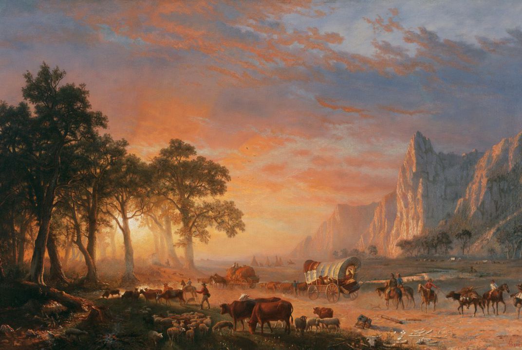
A painted depiction of the Oregon Trail by Albert Bierstadt 1869. (Creative Commons)
–
Any child of the 1980s is familiar with the basic skeleton of the Oregon Trail, from the celebrations warranted by a sight of Chimney Rock to the dangers of running a team of oxen at a grueling pace with meager rations. But even devoted players of the classic computer game, which turned 45 this year, may not know that relics of the trail itself are still carved into the landscapes of the United States.
The trail itself—all 2,170 miles of it—was braved by more than 400,000 people between 1840 and 1880. Weighed down with wagons and their personal possessions, the pioneers that dared travel the Oregon Trail slowly helped build the United States’ western half. The trail began in Independence, Missouri, and continued to the Willamette Valley in Oregon, where pioneers could decide to either stay put or continue north or south and settle.
As the Oregon Trail evolved, thousands of wagons wore ruts into the ground that acted as an ad-hoc road for the settlers who followed. But they didn’t follow a single solid path. Rather, wagon wheels left ruts across the country as pioneers found various shortcuts and easier routes along the way. Many of those ruts still exist today, though some of them are in danger of destruction as municipalities push to stretch bigger and better power supplies across the region.
So caulk those wagons and get ready to ford the river. Follow this modern-day journey, stopping to see trail relics along the way—with no need to worry about typhoid fever or dysentery.
Red Bridge Crossing (Kansas City, Missouri)
Saved from tripadvisor.com
Minor Park, Kansas City: See 2 reviews, articles, and 1 photos of Minor Park, ranked No.104 on TripAdvisor among 127 attractions in Kansas City. 64 Sarah Mandeville Places to Go…..
These ruts are not so obvious to the untrained eye—the site is a swale, or a sunken trail eroded into the hillside, caused by wet wagon wheels coming out of the Big Blue River. This was the first river crossing pioneers hit on the trail; they often had to camp here and wait for the river to reach the right height to cross.
Alcove Spring (Blue Rapids, Kansas)
Alcove Springs was a stop along the Oregon Trail / California Trail near – Blue Rapids, Kansas. The Donner Party camped here from May 26-30 1846 – 165 Steven Cone Hist. – Wagons Trains West
This spot’s unique rock formations, waterfall, and natural spring were a favorite stopping point for pioneers after crossing the Big Blue River. Many wanted to leave their mark and carved their names into the rocks around the spring—including Edwin Bryant, a member of the famously doomed Donner-Reed Party. According to Bryant, his group actually named the area “Alcove Springs” and carved the name into the rocks and surrounding tree trunks.
California Hill (Brule, Nebraska)
Saved from oregontrail2012.files.wordpress.com
California Hill, Nebraska. The Platte River splits into two forks, the South Platte what runs toward Denver, and the North Platte towards South Pass. Of all the crossing sites, the upper crossing was most important as it led directly to Ash Hollow, the best approach to the North Platte. 187 Jaime Lee Moyer – Gold rush days
Pioneers faced a hefty climb up California Hill after crossing the South Platte River. Right after reaching the other side of the water, wagons had to drive up 240 feet in a little more than a mile and a half, leaving deep ruts up the hill that are still visible today. Almost everyone on the Oregon Trail had to take this route, and California Hill was the first major climb they encountered on the trail.
Rock Creek Station (Fairbury, Nebraska)
Rock Creek Station, Nebraska Unforgettable memories from trail rides on the original Oregon Trails…128 Linda Dahlberg – My travel diary
Pristine trail ruts stretch
1,600 feet through the countryside here at Rock Creek Station. The spot was originally established as a supply stop and eventually became a Pony Express station. A
toll bridge built specifically for the pioneers crossed a creek here—before the bridge, travelers had to lower their wagons into the creek and hoist them out. The bridge solved the problem, allowing settlers to skip the heavy lifting while paying 10 to 50 cents to cross at road level; the toll was based on load size and ability to pay.
Guernsey Ruts (Guernsey, Wyoming)

Oregon Trail Ruts by Kathy Weiser-Alexander
The tracks at Guernsey are among the most impressive remnants of Oregon Trail history. Almost every pioneer had to pass through the same spot here, going over soft sandstone. Over time, each wagon wore down the rock a bit more…and more…and more. The ruts eventually became five feet deep, and visitors can walk through them for a real pioneer experience. South of Guernsey is Register Cliff, where many pioneers carved their names into the rock to document their passage.

Register Cliff. Wyoming SHPO photo.

Names on Register Cliff. Wyoming Tales and Trails
Independence Rock (Casper, Wyoming)
The first Europeans to visit the rock were members of Robert Stuart’s expedition in 1812. It is Stuart who is generally credited with discovery of the route, which became known as the Oregon Trail. Stuart’s diary indicated that he visited the site on October 30, 1812. 314WyoStateParks Independence Rock State Historic SiteMany pioneers passing by Independence Rock stopped here to carve their names into the granite, earning it a title of one of the “registers of the desert,”
given by Father Peter J. DeSmet in 1840. The landmark was christened Independence Rock in 1830 when
William Sublette passed through with his wagon train, noting he’d made it there by July 4—if wagon trains didn’t make it by then, they
weren’t likely to reach their final destination by winter.
The first Europeans to visit the rock were members of Robert Stuart’s expedition in It is Stuart who is generally credited with discovery of the route, which became known as the Oregon Trail. Stuart’s diary indicated that he visited the site on October 30, 1812.
Big Hill (Montpelier, Idaho)
Saved from oregontrailcenter.org
Big Hill, Idaho (modern reenactment from Oregon Trail center) Not long after emigrants crossed Thomas Fork Creek in Idaho, they faced one of the steepest decents along the entire trail. Coming down was more difficult than going up. 179 Jaime Lee Moyer – Gold Rush DaysUntil 1852, when the McAuley Road cutoff was blazed, pioneers had to face the challenge of Big Hill. The
longest, steepest climb on the Oregon Trail, the hill had an even more dangerous descent. Tracks are still visible going up the hill, and are also visible on the way back down, into Bear River Valley. They’re best viewed a bit farther away from the highway—up close you don’t see the magnitude of what the pioneers endured on this part of the trail.
Virtue Flat (Baker City, Oregon)
Saved from superstock.com
Stock Photo 1566-0132974: Download Oregon trail ruts along Highway 86 at Flagstaff Hill. Baker City, Oregon.
Oregon trail ruts along Highway 86 at Flagstaff Hill. Baker City. Oregon. USA 97 Authentic Destinations Oregon–Just below the modern-day National Historic Oregon Trail Interpretive Center on Flagstaff Hill—where pioneers got their first glimpse of the Baker Valley—seven miles of wagon ruts are visible across the ground. This site has what might be the first passing lanes in the west; some of the ruts run
parallel to one another, implying that some wagons passed others going slower in order to get to Powder River first.
Columbia River Gorge (Biggs Junction, Oregon)
Oregon Trail ruts near Biggs Junction, Oregon by Steve_Riddle2K+Rhonda Magic USA ~ Oregon–Along the freeway here, an Oregon Trail historic sign sits on a
cliff face next to one of the final sets of wagon ruts along the route to Columbia. These stretch up a hill on the side of the road and go along the cliff for about a mile, leading to an impressive view of the Columbia River.
–

")