–
By Ashley Cowie, 2020 Jun 16 –
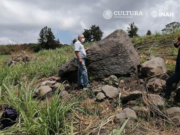
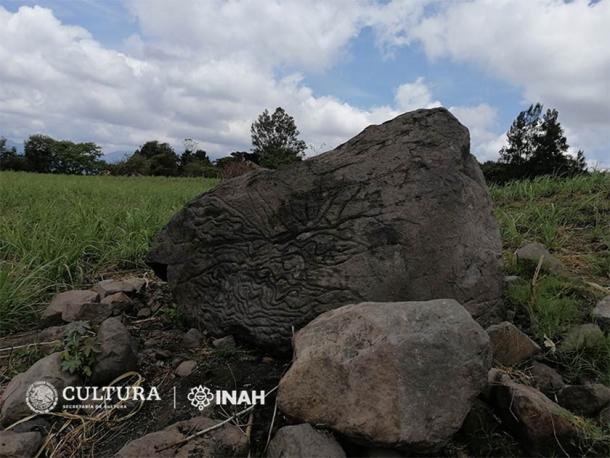
Archaeologists from El Instituto Nacional de Antropología e Historia (INAH) have confirmed the discovery of an ancient stone map carved into a volcanic rock in Colima, México dating from between 200 BC and 200 AD. Carved on the face of a 1.7 meter-high (5.77 ft) basalt volcanic rock, that had been ejected from a prehistoric eruption at the Colima volcano some 14 kilometers (8.7 miles) away, the map’s small carved circular features show the position of ancient settlements. According to researchers, the map represents the territorial organization within a group of indigenous, Pre-Columbian, native settlements around Colima.
 Staff from the INAH Colima Center inspecting the newly discovered Mexican stone map that predates the Chanal or Postclassic Colimense phase (1000–1500 AD) . (Image: Arqlgo. Rafael Platas Ruiz. INAH-Colima)
Ancient Mexican Map Stones and Why They Are Significant
Julio Ignacio Martínez de la Rosa, head of the INAH, said the significance and meaning of the new stone map was based on “a study of the designs and patterns as well as a comparison to similar petroglyphs found in the region.” The map contains both orographic and hydrological features. The carved hollows, representing locally situated villages, and a series of lines between the ancient settlements were found to correspond with the geographical landscape of the southern slope of the Colima volcano, with ravines and rivers all clearly apparent.
Archaeologists determined that the context dating of the newly discovered map does not correspond with the Chanal or Postclassic Colimense phase (1000–1500 AD). Instead, the new map style is more closely aligned with early tombs from the Late Pre-classic and Early Classic periods between 200 BC and 200 AD. Archaeologist Rafael Platas Ruiz said these “map-stones” undoubtedly helped indigenous people to understand and facilitate the management of their territory and that they were a way of preserving knowledge from one generation to another at a time when writing did not exist.
 Petroglyph used as a ‘stone-map’ over two thousand years ago, in Colima. (Rafael Platas Ruiz / INAH-Colima)
Interpreting Ancient Stone Maps to Find Cosmological Beliefs
Rafael Platas Ruiz is known for his highly original “interpretation of volcanic carved maps.” In January 2018, Ancient Origins reported on a mysterious stone pond discovered at 13,000 feet on the side of Iztaccihuatl volcano in México, that Ruiz identified as a “1,000-year-old map of the universe.”
At the Iztaccihuatl volcano site, known as “Nahualac,” INAH archaeologists unearthed decorative pieces of pottery with iconography associated with the rain god Tlaloc. Moreover, the specific placement of the stones surrounding the 1,000-year-old sacred structure reflected meso-American cosmological beliefs. This led researchers to conclude that this ancient shrine may have been based on the myth of the mythological Earth monster, “Cipactli,” that floated on primeval waters and then split itself in two, creating heaven and earth.
- Cave Art in the Dark: Thousands of Indigenous Pre-Columbian Paintings Brought to Light
- The Lost Zapotec: Vibrant Mesoamerican Civilization of The Cloud People
- Pre-Columbian Murals and Norse Sagas Suggest Vikings Met the Aztecs, and the Outcome Was Not Pretty

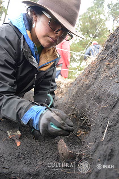
Archaeologist recovers pottery at Nahualac site, México. (Isaac Gómez, cortesía Proyecto Arqueológico Nahualac, SAS-INAH.)
Pre-1600 Manuscripts Shed New Light on Pre-Hispanic Symbols
The two ancient maps mentioned above describe the layouts of ancient societies and cosmo-mythological realms. A 2016 Smithsonian article describes another priceless Mexican map: the digitized 400-Year-Old “Codex Quetzalecatzin,” dating back to the late 1500s that was acquired by the Library of Congress. Regarded as one of the most important surviving Mesoamerican manuscripts from the 16th century, the Codex Quetzalecatzin is a colorized map revealing detailed insights into life in Mesoamerica during the period of early Spanish colonization, featuring pre-Hispanic symbols for rivers, roads and pathways.
Fewer than 100 illustrated pre-1600 Mesoamerican manuscripts exist today, and for this reason the Codex Quetzalecatzin documents an important part of Mexican history by “capturing” the first interactions between Mesoamerican and European cultures. According to curator John Hessler in a blog post on the codex for the Library of Congress, “Codices such as these are critical primary source documents,” detailing the history and ethnography during the earliest periods of contact between Europe and the peoples of the Americas.
Since ancient maps offer important clues into how different cultures originated, and ultimately how cultures integrated and adapted to one another, the discovery of the recently interpreted volcanic rock map in Colima, dating from between 200 BC and 200 AD, can rightfully be described as archaeologically significant.
–
(For the source of this, and many other equally intriguing articles, and to watch a video about indigenous mapping, please visit: https://www.ancient-origins.net/news-history-archaeology/stone-map-mexico-0013864/)


