
")


Archaeologists have used laser technology to map a 100-km (62-mile) Maya stone road that could have been built 1,300 years ago to help with the invasion of an isolated city in modern-day México. The ancient highway is thought to have been constructed at the command of the warrior queen Lady K’awiil Ajaw, and would have been coated in white plaster.
The 26 ft (8 m)-wide road, also known as Sacbe 1 or White Road 1, stretches from the ancient city of Cobá – one of the greatest cities of the Maya world – to the distant, smaller settlement of Yaxuná, located in the Yucatán Peninsula.
Newly-published research has shed new light on the nature of Lady K’awiil Ajaw’s great road by making use of light detection and ranging, otherwise known as LiDAR technology. To take their measurements, the authors made use of an airborne LiDAR instrument, which beamed lasers at the surface as it passed over the ancient road.
These lasers hit the ground and bounced back to the instrument, which recorded the elapsed time between emitting the light and detecting its return. By analyzing this data, the scientists were able to make detailed 3D maps of areas that are ordinarily shrouded by impenetrable jungle.
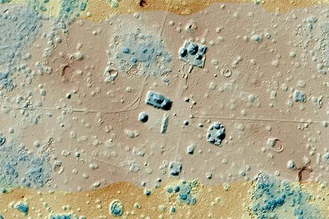
The LiDAR scans uncovered 8,130 structures clustered along the ancient road. In the paper, it is estimated that their combined volume would fill 2,900 Olympic-sized swimming pools.
–
Instead of running straight, as was previously thought to be the case based on measurements taken in the 1930s, the LiDAR data also revealed that the vast road curved around a number of towns and cities on the way to its final destination. This suggests that the road would likely have formed an arterial highway, connecting the thousands of people living in the region.
The authors of the study hypothesize that the road could have been built by Lady K’awiil Ajaw to pave the way for territorial expansion, in order to answer the threat from the encroaching Chichén Itzá empire. Cobá may have been looking to occupy the isolated city of Yaxuná in the center of the peninsula, in order to gain a foothold against the rising threat.
“It was built just before 700, at the end of the Classic Period, when Cobá is making a big push to expand,” said Traci Ardren, an archaeologist and professor of anthropology at the University of Miami, and co-author of the new study. “It’s trying to hold on to its power, so with the rise of Chichén Itzá, it needed a stronghold in the center of the peninsula. The road is one of the last-gasp efforts of Cobá to maintain its power.”
As part of the study, the team excavated clusters of buildings located along the boundary of the cities of Cobá and Yaxuná, and are planning a third dig in the coming summer. Their goal is to establish a similarity in the type of household goods used throughout the two distant population centers.
The paper has been published in the Journal of Archaeological Science.
Source: University of Miami
–
(For the source of this, and many other equally intriguing articles, please visit: https://newatlas.com/science/archaeology-laser-lidar-maya-road/)