
")


 A snowflake is a small weather feature that can pack a big punch.
 –
2020 Dec 23
–
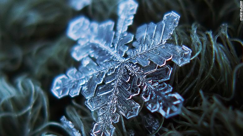
Many are made up of just one single ice crystal while some, more elaborate snowflakes are comprised of as many as 200 ice crystals fused together.
–
All flakes maintain the same six-sided basic shape, though no two snowflakes will have exactly the same arrangement of molecules.
–
–
This makes each one unique.
–
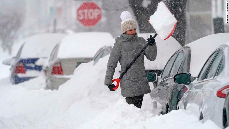 A woman tosses a shovel full of snow while digging out her car on 2020 Dec 17, in Manchester, New Hampshire.
–
–
 A woman tosses a shovel full of snow while digging out her car on 2020 Dec 17, in Manchester, New Hampshire.
–
No two snowflakes are the same
–
Like fingerprints, no two snowflakes are exactly alike. In fact they are so diverse, there is actually an international classification system for snowflakes. This system is broken down into mostly eight principal snow crystal types: stellar dendrites, sectored plates, rimed crystals, hollow columns, needles, spatial dendrites, capped columns and irregular forms.
–
To understand how they get their unique shape, we must start at the beginning. A snowflake first forms when an extremely cold water droplet freezes onto a pollen or dust particle in the sky.
–
–
“This creates an ice crystal,” according to the National Oceanic and Atmospheric Administration (NOAA). “As the ice crystal falls to the ground, water vapor freezes onto the primary crystal, building new crystals — the six arms of the snowflake.”
–
–

Each individual snowflake encounters slightly different atmospheric conditions on its path from sky to ground. Therefore, they all end up unique, while still maintaining the basic six-sided structure.
–
–
“Ultimately, it is the temperature at which a crystal forms — and to a lesser extent the humidity of the air — that determines the basic shape of the ice crystal. Thus, we see long needle-like crystals at 23 degrees F and very flat plate-like crystals at 5 degrees F. ”
–
–
Although the core six-sided shape is always maintained, each of the six arms may branch off in new directions, or change shape as it incurs slight changes in the surrounding temperature or humidity, but because each of those arms is experiencing the exact same atmospheric conditions, all the arms will look identical.
–
Cold air is paramount
As the famous quote says “To appreciate the beauty of a snowflake it is necessary to stand out in the cold.”
–
–
The temperatures at the surface are only part of the story though. You really have to look at the entire column of air to know what type of precipitation you will get.
–
–
Most precipitation that forms in wintertime clouds starts out as snow because the top layer of the storm is usually cold enough to create snowflakes. Precipitation continues to fall as snow when the temperature remains at or below 32 degrees F from the cloud base to the ground.

–
–
“While it can be too warm to snow, it cannot be too cold to snow. Snow can occur even at incredibly low temperatures as long as there is some source of moisture and some way to lift or cool the air. It is true, however, that most heavy snowfalls occur when there is relatively warm air near the ground—typically 15 degrees F (-9 degrees C) or warmer—since warmer air can hold more water vapor.”
–
–
The NSIDC explains that while most snowflakes are less than 0.5 inches across, some can reach sizes nearing 2 inches across. In order to get such large snowflakes, however, you need very specific weather conditions including near-freezing temperatures, light winds and unstable atmospheric conditions.
–
Frozen precipitation and travel do not mix well
What’s interesting about snowflakes is that independently they are quite delicate, but in large enough quantities they can shut down a city.
Snow isn’t the only form of frozen precipitation, but it is the most complex. In addition to snow, you can also have sleet, freezing rain, hail and graupel.
 This diagram shows different types of precipitation.
 –
Graupel occurs when supercooled water droplets collect on the outer surface of snowflakes. It happens when temperatures at the surface are above freezing and the air aloft is very cold.
–
–
Sleet is actually just rain (liquid precipitation) that freezes on its way down to the ground as it hits cooler pockets of air near the surface.
–
–
Hail is actually falling raindrops that get caught up in a thunderstorm’s strong updraft winds. They then get carried aloft into the coldest part of the cloud tops and freeze.
–
–
If you are driving you can actually hear graupel and sleet as they hit your windshield of your car because of their composition. It tends to make a “tap, tap, tap” sounds as it hits the glass and bounces slightly.

A snowplow pushes snow near Times Square on 2020 Dec 17 in New York, the morning after a powerful winter storm hit the US northeastern states.
Hail also makes noise, but more importantly, it can cause significant damage to a vehicle because they are usually much larger in size.
–
–
Freezing rain is when the entire column of air is warm and the surface is at or below the freezing mark, resulting in rain actually freezing on contact. This is one of the more dangerous kinds of precipitation because if you are out walking or driving, it appears as though it is just raining. However, what you can’t see is that those rain drops are turning into ice as soon as they make contact with the road, sidewalk or even your vehicle.
-
-
-
-
Age no barrier to ‘China’s hottest grandpa’
–
–
(For the source of this, and many other equally intriguing articles, please visit: https://www.cnn.com/2020/12/23/weather/weather-science-behind-snowflakes-scn-trnd/index.html/)
-
-

