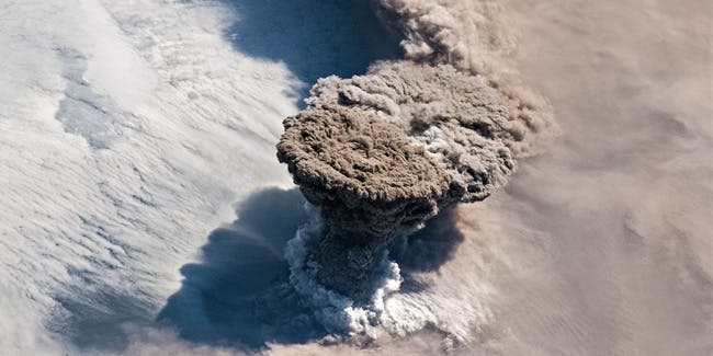
The full fury of Mother Nature was captured on camera by the current crew of the ISS.
–
A towering mushroom cloud of ash and smoke rose from a volcano in the Pacific Ocean so high that an astronaut aboard the International Space Station was able to take this stunning photograph capturing the might of Mother Nature.
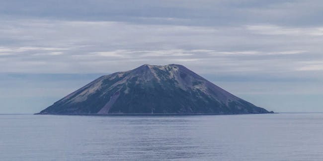
In an archipelago of volcanic peaks between Russia’s Kamchatka Peninsula and Japan’s Hokkaido Island, the volcano Raikoke sits on one of the Kuril Islands. About 4 a.m. local time on Saturday, June 22, Raikoke exploded for the first time since 1924, expelling a dense plume that could be seen from low Earth orbit, according to the NASA Earth Observatory.
The towering plume extended to an altitude of about 43,000 feet as it rose from the volcano’s crater and formed a thin column that puffed out at the top, like a thermonuclear mushroom cloud. To compare height, Mount Everest is 29,000 feet high, and commercial airliners soar at an altitude of 35,000 feet.

The Kuril Islands form a chain that’s part of the ring of tectonic instability that encircles the entire Pacific Ocean, often referred to as “the Ring of Fire.” The chain has around 100 volcanoes, some 40 of which are active, plus many hot springs and fumaroles. Despite Raikoke having been dormant for nearly a century, there is still frequent seismic activity, including a magnitude 8.3 earthquake recorded on November 15, 2006, which resulted in tsunami waves up to five feet, reaching the California coast.
Raikoke is what’s called a stratovolcano, which means its slopes are built up from numerous layers of hardened lava and ash. At its highest point, it stands 1,808 feet above sea level and prior to the 1924 eruption, the volcano’s last recorded activity was in 1778.

“What a spectacular image. It reminds me of the classic Sarychev Peak astronaut photograph of an eruption in the Kuriles from about ten years ago,” Michigan Tech volcanologist Simon Carn said in a statement. “The ring of white puffy clouds at the base of the column might be a sign of ambient air being drawn into the column and the condensation of water vapor. Or it could be a rising plume from interaction between magma and seawater because Raikoke is a small island and flows likely entered the water.”
According to NASA, in this highest zone of a volcanic plume – known as the umbrella region – the ash cloud’s density equalizes with the density of the air around it and the plume’s rise slows and then stops, forming the distinct shape that we’ve seen.

Because the ISS photo was taken at an angle and not directly above the volcano, the full scale of the ash plume is apparent, as is the shadow cast by the plume on the cloud cover far below.
However, a day or so after the eruption, storm winds in the Pacific pulled the ash cloud to the east as can be seen in another photograph — above — taken from the ISS.
(For the source of this, and many other interesting and important articles, please visit: https://www.inverse.com/article/57109-volcanic-cloud-visible-from-space/)


